
Welcome back to the continuation of my series on early Chinese sources on Southeast Asia’s eastern archipelago. This is the fourth part of the series. If you have not read the previous three posts, I recommend doing so.
Unlike the earlier posts, this installment does not introduce a new collection of online resources. However, I still felt it necessary to include a post on one important text titled A Brief Account of Island Barbarians (Dǎo Yí Zhì Lüè 島夷誌略) written in the mid-fourteenth century by Wāng Dàyuān (汪大淵). The Chinese text is available through both Wikisource and the Chinese Text Project. Perhaps the point worth celebrating here is simply how many historical Chinese texts are now freely accessible from anywhere in the world. Hooray for digital humanities!
I am not aware of a complete English translation of A Brief Account of Island Barbarians, although several partial translations exist. For the eastern archipelago, I periodically consult William W. Rockhill’s translation and commentary, published in 1915. This edition requires some caution. Rockhill rearranged the entries geographically according to his identifications of the places described, drawing on earlier scholarship, including the work of W. P. Groeneveldt. His organization is useful, but it also builds particular interpretations into the presentation of the text.
To begin with, a few comments on the title of this text. 島 (dǎo) means “island”. 夷 (yí) does mean something akin to “barbarian”. Ancient Chinese texts, as far back as the Zhou (周) Dynasty (c. 1046-256 BCE) refer to the “Four Barbarians” (sìyí 四夷) that resided in a different cardinal direction relative to them. These four barbarians included the “Eastern Barbarians” (Dōngyí 東夷), the “Western Barbarians” (Xīróng 西戎), the “Northern Barbarians” (Běidí 北狄), and the “Southern Barbarians” (Nánmán 南蠻 ).
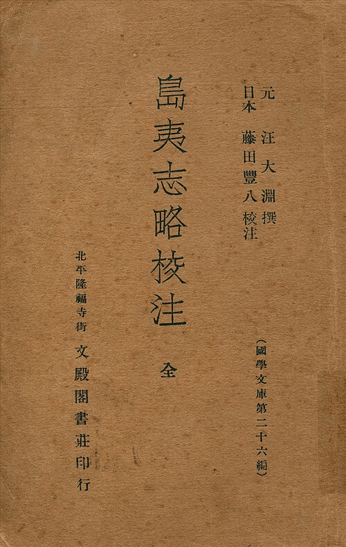
(Wikimedia Commons)
These labels did not designate clearly defined or unchanging ethnolinguistic groups, although scholars have attempted to identify the various peoples to whom they were applied in particular periods. Notably, each label employs a different term conventionally translated as “barbarian.” The written forms of these characters have sometimes encouraged suggestive interpretations. 戎 (róng) contains components associated with weapons. 狄 (dí) combines 犭, the “animal” component, with 火, “fire”. And 蠻 (mán) contains 虫, a component associated historically with insects, reptiles, and other creeping creatures. The graph 夷 (yí) has likewise traditionally been interpreted as combining elements associated with a bow and arrow. Over time, 夷 became a particularly broad designation for non-Chinese or culturally peripheral peoples. Accordingly, the title may be translated as A Brief Account of the Island Barbarians.
Written more than a century after Zhao Rukuo’s (趙汝适) Gazetteer of Foreign Lands (Zhū Fān Zhì 諸蕃志), discussed in the previous post, Wang’s account offers further information about the eastern archipelago. Three entries are particularly relevant here: 文誕 (Wéndàn), 古里地悶 (Gǔlǐ Dìmèn), and 文老古 (Wénlǎogǔ). Rockhill identifies these with Banda, Timor, and Maluku, respectively (pp. 256–260).
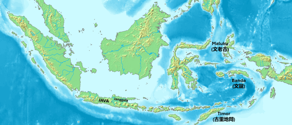
As always with these sources, these identifications remain speculative. I have provided my transliteration notes below:
文誕 – Banda
Mandarin (Hanyu Pinyin): Wéndàn
Hokkien (Pe̍h-ōe-jī): bûn-tàn
Cantonese (Jyutping): man4 daan3
Middle Chinese (Baxter): mjun danX
古里地悶 – Timor
Mandarin (Hanyu Pinyin): Gǔlǐ Dìmèn
Hokkien (Pe̍h-ōe-jī): kó͘-lí-tē-būn; kó͘-lí-tī-būn
Cantonese (Jyutping): gu2 lei5 dei6 mun6
Middle Chinese (Baxter): kuX liX dijH mwonH
文老古 – Maluku
Mandarin (Hanyu Pinyin): Wénlǎogǔ
Hokkien (Pe̍h-ōe-jī): bûn-ló-kó͘; bûn-lāu-kó͘
Cantonese (Jyutping): man4 lou5 gu2
Middle Chinese (Baxter): mjun lawX kuX
These readings are points of comparison rather than a reconstruction of exactly how Wang or his informants pronounced the names.
The identification of 文誕 (Wéndàn) with Banda may not seem immediately convincing, even when considering a Hokkien reading resembling “Bun-tan.” A useful comparison, however, appears in the fourteenth-century Javanese Nagarakṛtāgama, also known as the Deśawarṇana.
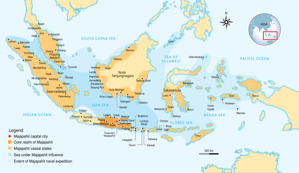
Listing the vassals and tributaries of the major Javanese polity of Majapahit in the eastern archipelago, the text includes:
Taking them island by island: Makasar, Butun and Banggawi,
Kunir, Galiyahu and Salaya, Sumba, Solot and Muwar,
As well as Waṇḍan, Ambwan, Maloko and Wwanin,
Seran and Timur as the main ones among the various islands that remember their duty.
(Mpu Prapañca, Deśawarṇana, trans. Stuart Robson, canto 14, p. 34)
The sequence “Waṇḍan, Ambwan, Maloko, Wwanin, Seran and Timur” is generally understood as referring to Banda, Ambon, Maluku, Onin in western New Guinea, Seram, and Timor. The form Waṇḍan makes the proposed connection between Banda and 文誕 more plausible. Perhaps I will return to these Javanese texts in a later post. (After I learn some Javanese first!)
Wang describes 文誕 as a source of nutmeg (肉荳蔻), mace (荳蔻花), and enslaved people (黑小廝). The last term can be rendered literally as “black young servants,” although “servants” obscures the coercion implied by their inclusion among commodities. 小廝 refers to a boy or young male servant and can carry a disparaging tone.
The entry commonly identified with Timor appears under the name 古里地悶 (Gǔlǐ Dìmèn). I am unsure what the first two characters, 古里 (Gǔlǐ), represent. Although 古 means “old” or “ancient,” individual characters in a transcribed place name need not retain their ordinary meanings. They may instead approximate a local name or a form used by visiting sailors. 古里 could have sounded something like “Ko-li” in Hokkien or “Ku-li” in Middle Chinese. I would welcome further insight into this part of the name.
Wang places 古里地悶 northeast of 加羅 (Jiāluó). Rockhill suggests that 加羅 refers to 重迦羅 (Zhòngjiāluó), which Wang elsewhere describes as bordering 爪哇 (Zhǎowā), generally identified with Java. Readings of 重迦羅 resembling “Tang-khia-lo” in modern Hokkien or “Diong-kya-la” in Middle Chinese suggest a connection with Janggala, a historical polity in northeastern Java, around present-day Surabaya.
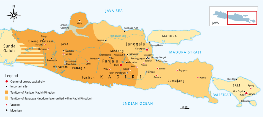
The direction presents a problem: Timor lies east and somewhat south of Java. Perhaps “northeast” reflects part of a sailing route rather than a direct geographic bearing. A ship might have sailed northeast from eastern Java before continuing east along the northern coasts of the Lesser Sunda Islands and eventually turning south toward Timor. This explanation remains conjectural, however.
Stronger support for identifying 古里地悶 with Timor comes from Wang’s description of abundant sandalwood trees (檀樹). Yet his account also offers a stark warning about trading there. He describes merchants contracting fatal illnesses and recounts a voyage on which most of the crew reportedly died.
The place recorded as 文老古 (Wénlǎogǔ) likely refers to the islands of present-day North Maluku, the original geographic referent of the name Maluku. Wang Dayuan identifies the islands as a source of cloves (丁香), noting that their “trees cover the mountains, but they do not bear regularly. They ripen in two or three years” (其樹滿山,然多不常生,三年中間或二年熟). He then describes how the inhabitants eagerly awaited Chinese trading vessels, which he calls “Tang ships” (唐舶). This is followed by an account of divination in which the hatching of chicks foretold the arrival of ships and how many ships arrived.
Across these entries, Wang lists goods exchanged for the eastern archipelago’s commodities, including ceramics, textiles, iron, musical instruments, gold, and silver. These descriptions raise a larger question: were Chinese ships reaching the eastern archipelago during the thirteenth and fourteenth centuries?
In his 1992 article, “The Northern Trade Route to the Spice Islands”, Roderich Ptak examines the Chinese evidence for these connections. He considers routes linking China to the eastern archipelago through the Philippines, as well as routes through the Malay Peninsula and the western archipelago. These possibilities remind us that information and commodities could reach Chinese ports through several interconnected trading networks.
Wang may therefore have obtained some of his information from Chinese sailors who had visited these islands. Establishing how they acquired that knowledge and how accurately Wang recorded it is another matter. I am still not sure about the hatching of chicken eggs for divination purposes.
References
Mpu Prapañca. Deśawarṇana: (Nāgarakṛtāgama). Translated by Stuart O. Robson. Leiden: KITLV Press, 1995.
Ptak, Roderich. “The Northern Trade Route to the Spice Islands: South China Sea–Sulu Zone–North Moluccas (14th to Early 16th Century).” Archipel 43 (1992): 27–56.
Rockhill, W. W. “Notes on the Relations and Trade of China with the Eastern Archipelago and the Coast of the Indian Ocean during the Fourteenth Century. Part II.” T’oung Pao 16, no. 2 (1915): 236–71.


Leave a Reply